Historic Trails Research
| DISTANCES FOR PLACENAMES ON THE LOLO TRAIL NATIONAL HISTORIC LANDMARK |
|||||
| Landmark or Place Name |
Mile Marker |
Landmark or Place Name |
Mile Marker |
Landmark or Place Name |
Mile Marker |
| Kamiah |
000.0 |
Green Saddle Junction |
045.6 |
Rocky Point |
100.1 |
| Lolo Creek Crossing |
006.6 |
Deep Saddle |
047.9 |
Clearwater River Crossing |
103.3 |
| Junction to Weipe Prairie |
010.6 |
No-See-Um Meadows |
054.4 |
Pack Creek Crossing |
107.5 |
| Wilson Creek Crossing |
012.5 |
Bald Mountain |
058.7 |
Lolo Pass 1805 |
109.3 |
| Lolo Creek Campground |
020.3 |
Indian Grave Camp |
065.5 |
Lolo Creek Crossing |
113.1 |
| April Creek Crossing |
022.6 |
Serpent Creek |
069.7 |
Lolo Hot Springs |
116.0 |
| Dollar Creek Crossing |
028.0 |
Howard Camp (midpoint) |
072.9 |
Howard Creek Crossing |
127.3 |
| Fish Creek Crossing |
034.1 |
Indian Postoffice |
078.0 |
Grave Creek Crossing |
126.0 |
| Hungery Creek Crossing |
037.4 |
Spring Mountain |
083.1 |
Bear Creek Crossing |
130.8 |
| Obia Creek Crossing |
041.4 |
Cayuse Junction |
086.8 |
Woodman Creek Crossing |
133.2 |
| Foot of the Mountain |
043.0 |
Papoose Saddle |
095.9 |
Travelers Rest |
143.0 |
| MAP SET FOR THE LOLO TRAIL NATIONAL HISTORIC LANDMARK |
|
| MAP |
DESCRIPTION |
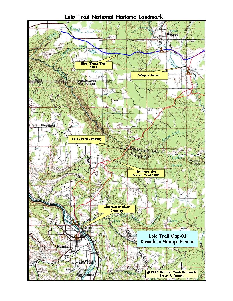
| MAP-01 Kamiah to Weippe Prairie |
The trail went north out of Kamiah, Idaho and over
the main ridge and down into Lolo, Creek. It crossed the creek and went through
table lands to the Weippe Prairie south of Weippe, Idaho.The trail branched
north of the Clearwater River. The eastern branch was the one used by Lewis
& Clark but it has been heavily used as a stock drive so the original
tread is gone. The age of the west branch is unknown but some of the original
tread still exists. There is great tread northward from the ridge down into
Lolo Creek but between the Lolo Creek Crossing and a mile or two south of
the Weippe Prairie, little tread remans due to logging and farming activities.
The trail split into two branches about a mile before reaching the Weippe
Prairie. The 1805-06 trail followed by Lewis and Clark went eastward before
reaching the Weippe Prairie. |
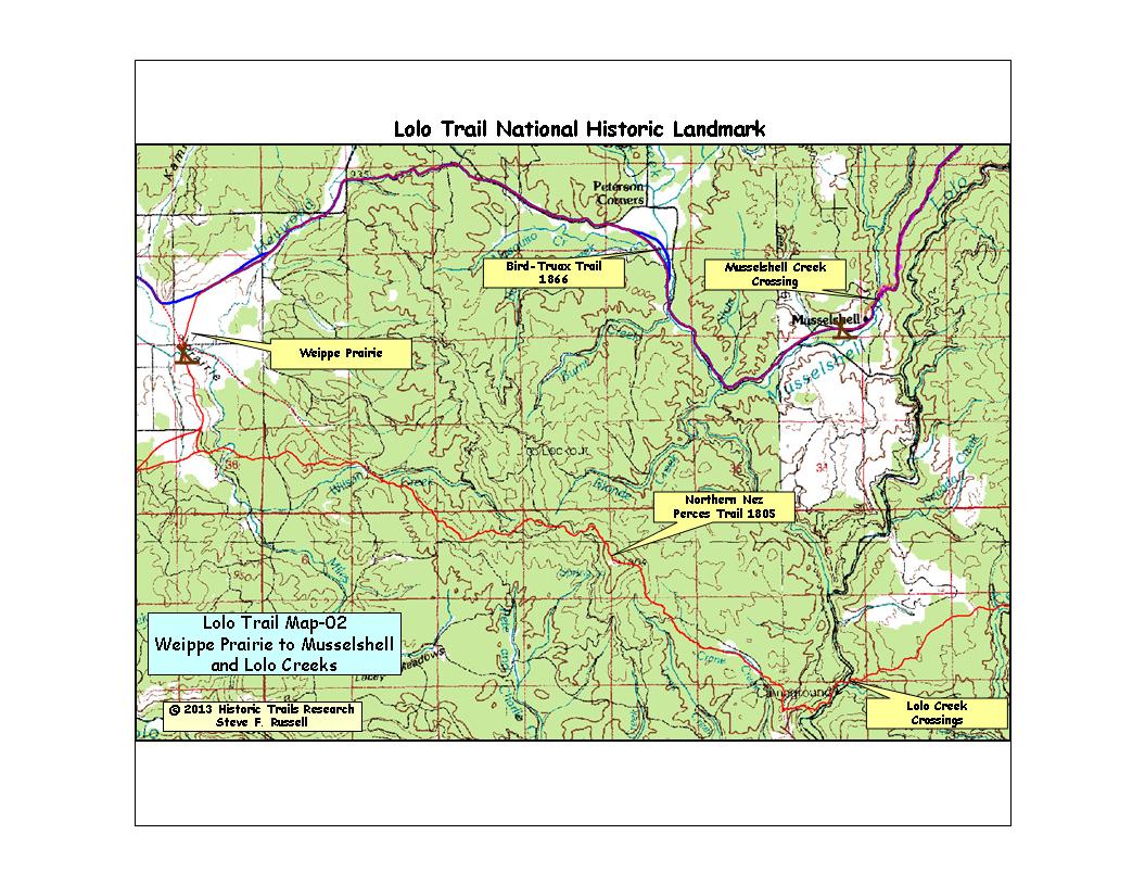
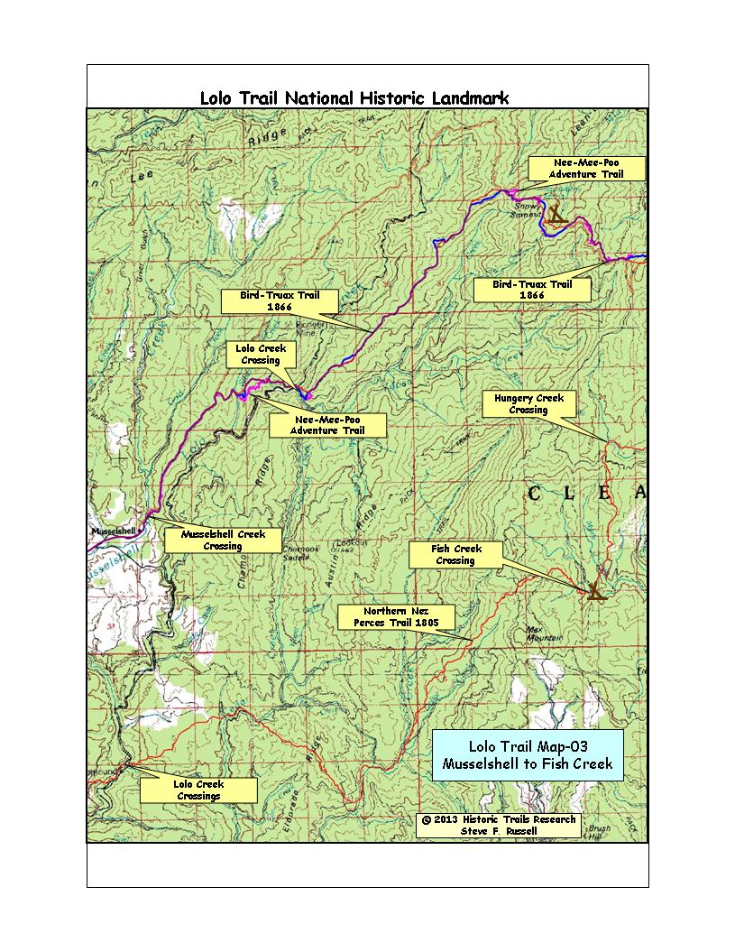
| MAP-02 Weippe Prairie to Musselshell |
The trail split into a northern branch and a southern
branch just before reaching the Weippe Prairie. The southern branch went
eastward to Lolo Creek, Fish Creek, and Hungery Creek before rejoining with
the northern branch near Green Saddle. The northern branch went through the
Weippe Praire and Musselshell Meadows before following the ridge system over
Snowy Summit and Rocky Ridge. It rejoined the southern branch near Green
Saddle. The branch followed by Lewis and Clark through Hungery Creek is rugged
and hard traveling. I think this is why trail use eventually migrated to
the northern branch which was the one used by John Work 1831, John Mullan
1854, Bird-Truax 1866, the 1877 Nez Perce war, and the US Forest Service. |
| MAP-03 Musselshell to Fish Creek |
See description above. |
| MAP-04 Fish Creek to Willow Ridge |
After joining east of Green Saddle, the trail system
does not split again until reaching Wendover Ridge and the Salish Salmon
Fishing Trail 1805. The Northern Nez Perces Trail 1805 and the Bird-Truax
Trail 1866 intermingle between Green Saddle and Lolo Pass but, at ground
level, their treads are distinct and separate for most of that distance.
The survey of the Bird-Truax Trail was done to a wagon road grade so it sweeps
around ridges and peaks, rather than going 'over the top.' The Northern Nez
Perces Trail is a very old horse trail so it up and down over the peaks and
along the ridges. Both treads are extant along this portion of the route. |
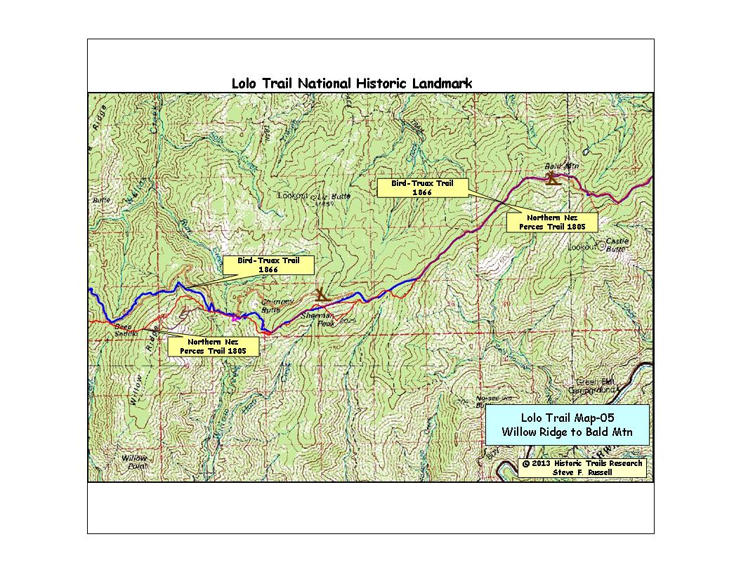
| MAP-05 Willow Ridge to Bald Mtn |
Between Willow Ridge and Bald Mtn, almost all the
erosion trace is extant. There are only short segments of missing tread for
either trail. The trails are tightly intermingled and frequently share the
same erosion trace. Most trail travelers, both historic and modern, considered
Bald Mountain to be the mid-point of the Lolo Trail but, between Kamiah and
Lolo, the midpoint is actually at Mocassin Peak, about 1 mile west of Howard
Camp. |
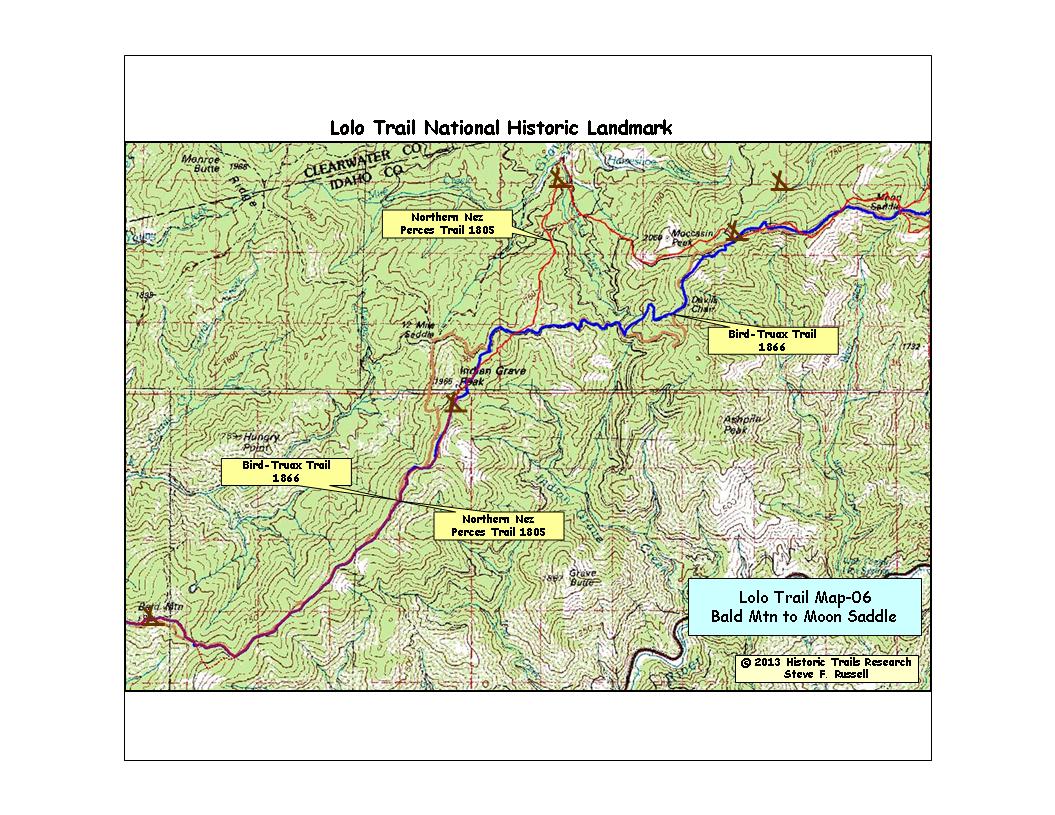
| MAP-06 Bald Mtn to Moon Saddle |
From Bald Mountain to Indian Grave. the trails are
mostly together and the erosion trace exists the entire route except for
a segment east of Bald Mountain which has been destroyed by road construction.
From Indian Grave to Moon Saddle, the erosion traces of the two trails are
distinct and separate. The Northern Nez Perces Trail leaves the ridge and
dips down into Serpent Creek. The Bird-Truax Trail 1866 stays on the ridge. |
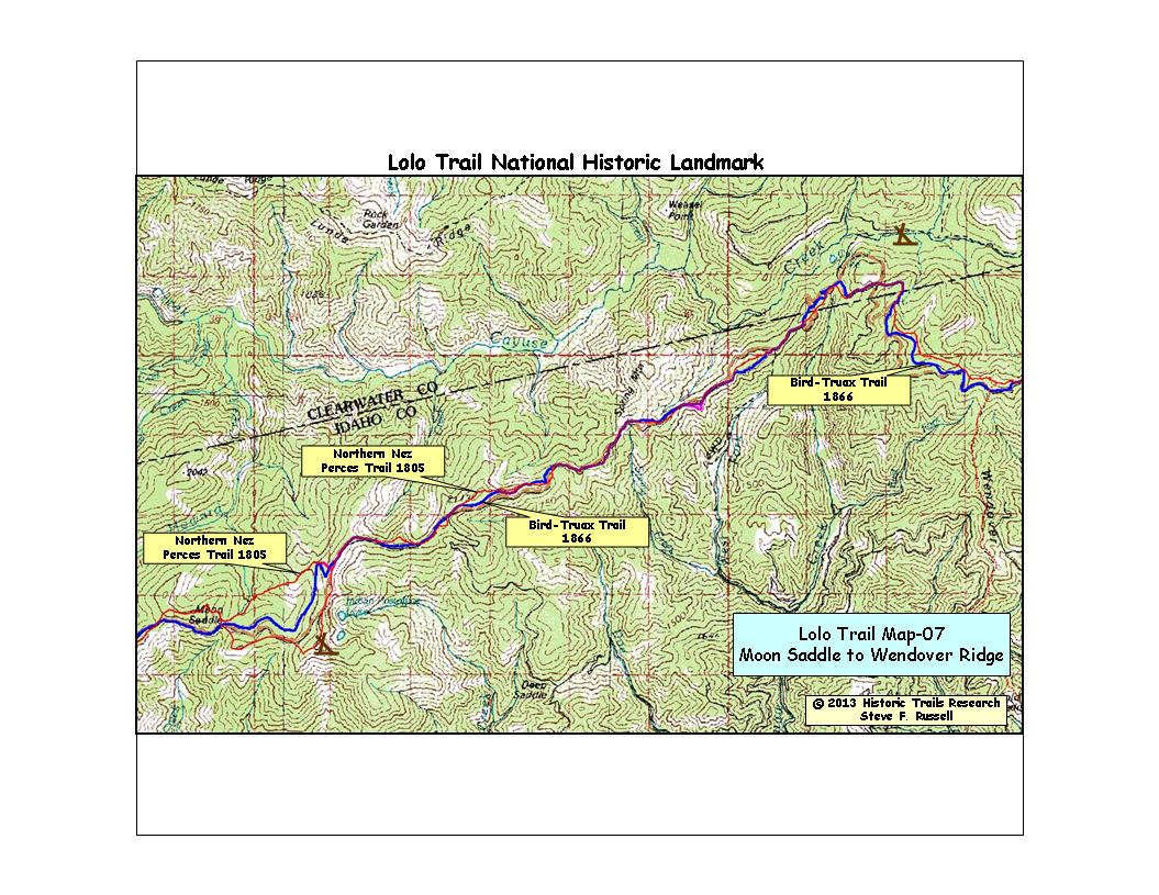
| MAP-07 Moon Saddle to Wendover Ridge |
The
two trails separate widely east of Moon Saddle but soon comingle again at
Indian Postoffice. This map as both the highest elevation on the Lolo Trail
(7000 feet at Indian Postoffice) and the steepest prolonged ascent (Cayuse
Junction to Snowbank Camp). The trail junction between the Northern Nez Perces
Trail and the Salish Salmon Fishing Trail is shown on the right edge of the
maps. The erosion traces and extant along this entire route except a very
few short segments where roads were built over the tread. Also, I have been
unable to locate any trail tread in the flat area of Cayuse Junction. |
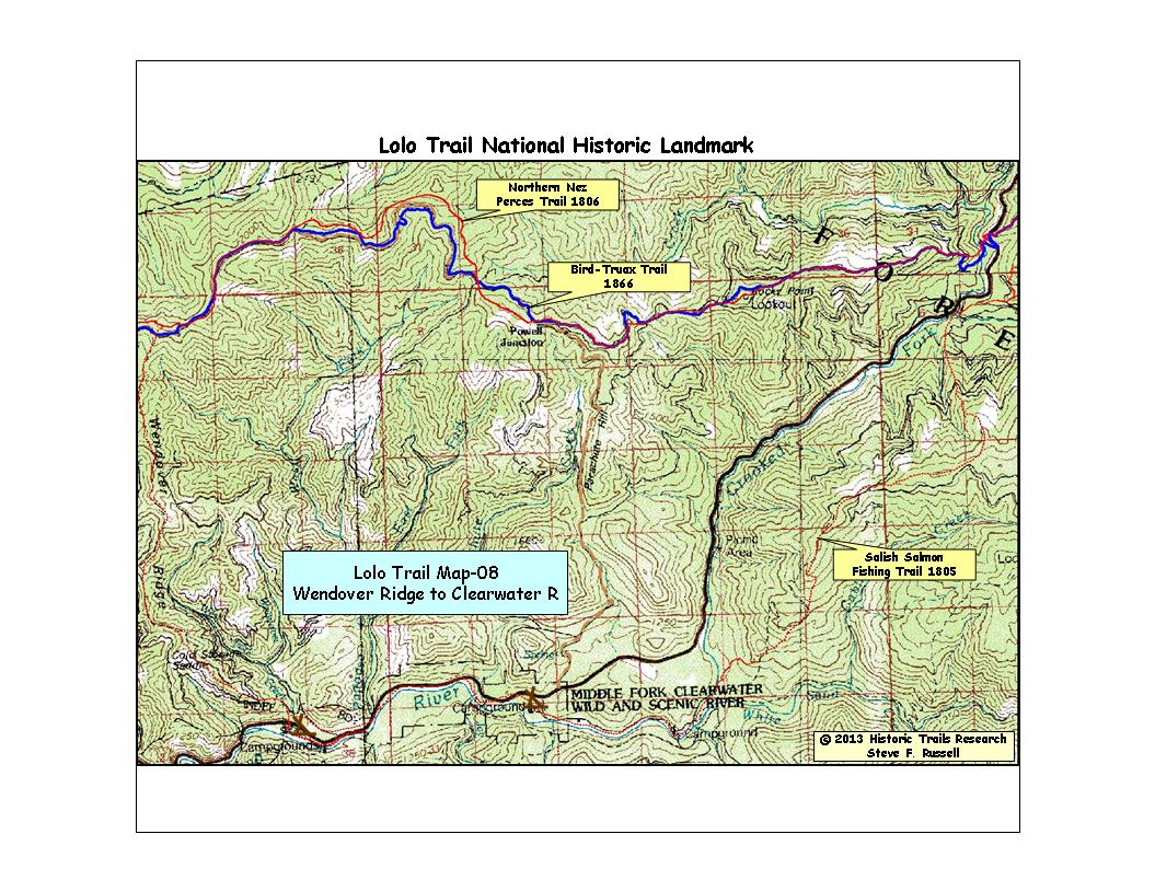
| MAP-08 Wendover Ridge to Clearwater River |
The Nez Perce trail stayed entirely on the tops of the ridges in this
area while the Bird-Truax Trail graded around the sidehills is several areas,
sometimes on the north side. I have been puzzled why they would site the
wagon road on the north side where the snow lingers many days longer in the
spring melt-off. Perhaps the surveyers came from flat country but they had
the wagon road builder, Sewell Truax with them so it remains puzzling. The
erosion traces are extant except for a small segment of the Nez Perce trail
northeast of Papoose Saddle and a small segment on the west side of the Crooked
Fork crossing. The Bird-Truax Trail is amazingly well routed into the canyon
to maintain the wagon road grade, however, on the east side, it is much steeper. |
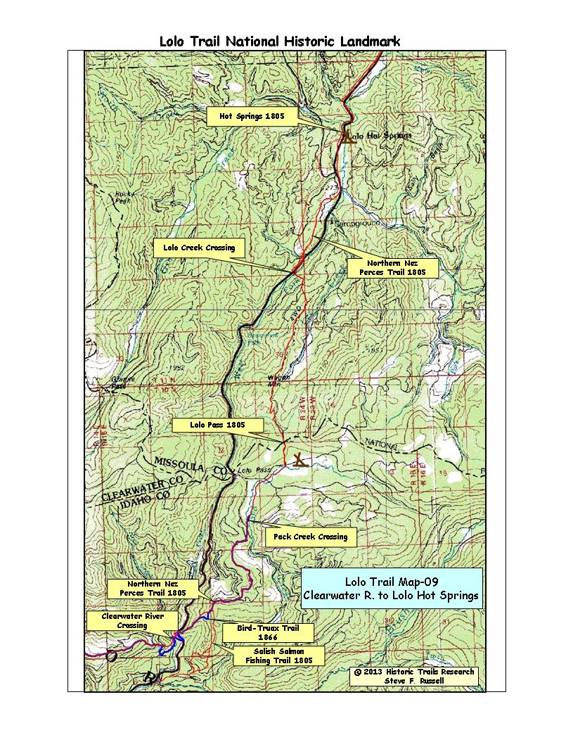
| MAP-09 Clearwater River to Lolo Hot Springs |
The Nez
Perce trail is as steep on the east side of Crooked Fork as it was on the
west side. The Bird-Truax Trail is also steep in spite of using switchbacks.
I have wondered if they did not really spend any detailed time surveying
the climb up the east side. Once the top of the ridge is reached, the slopes
are very gentle until the east side of Wagon Mountain is reached. The Bird-Truax
Trail ends the first time Pack Creek is crossed at Lewis & Clark Glade
Creek Camp. The rest of the way to Travelers Rest used the Nez Perce trail.
The trail is steep down into Lolo Creek. but then it follows down the creek
with a very gentle slope. |
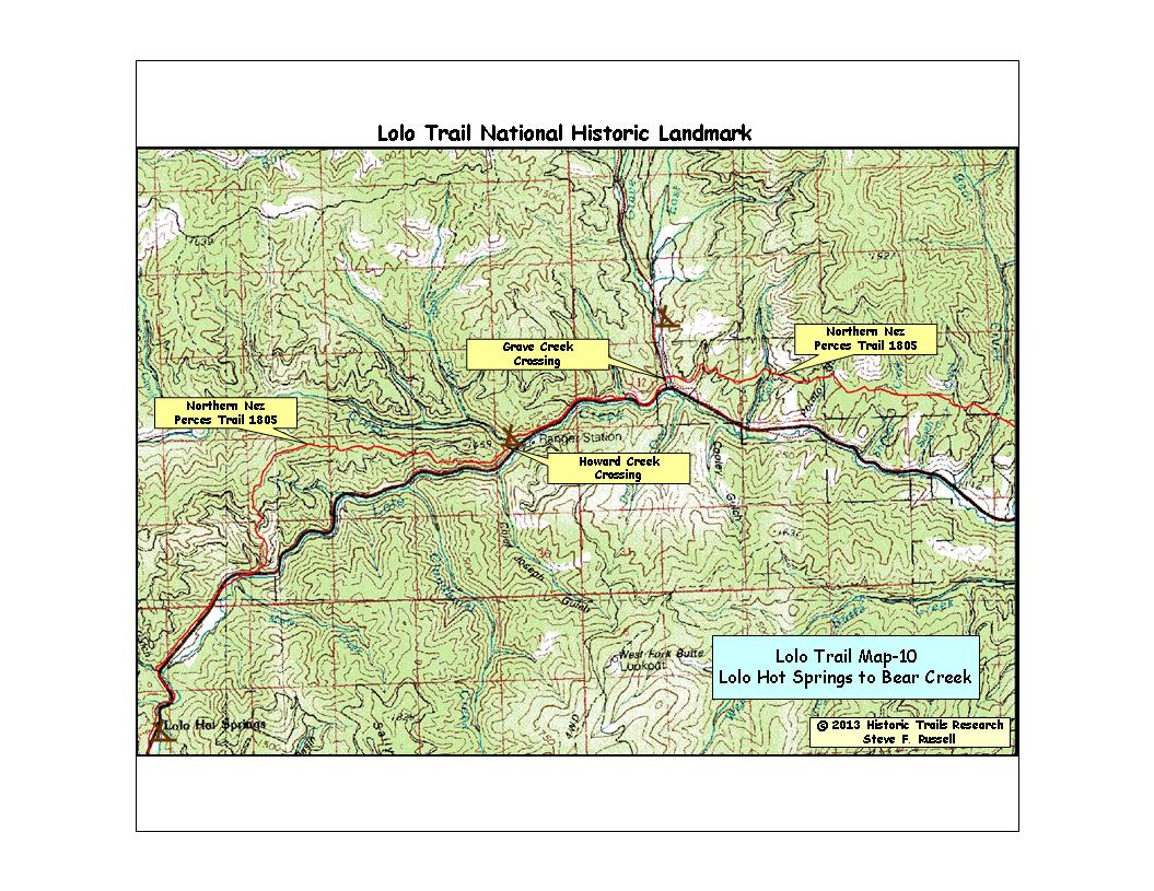
| MAP-10 Lolo Hot Springs to Bear Creek |
Along
this route, the trail stayed to the ridges and foothills to the north of
Lolo Creek to avoid the brush-choked creek bottom. There is very good trail
tread until just the west side of Grave Creek where ranching and road building
activities have obscured much of it. I have only hiked small portions of
the trail route east of Grave Creek because it is on private land. I was
able to find enough segments of tread to "connect the dots." |
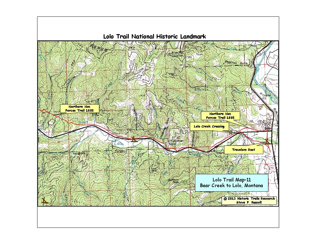
| MAP-11 Bear Creek to Travelers Rest (Lolo) |
The remainder of the route, from Bear Creek to Travelers Rest, I mainly relied on the excellent survey records from Bird-Truax
to locate the trail. I was able to find some very short segments of trail right along
the highway east of Woodman Creek.
I relied on interviews with 'old timers' on Lolo Creek to locate some of
the trail, especially as I got closer to Travelers Rest. |
Historic Trails Research, 26393 520th Ave, Ames, Iowa, 50014